Monday, May 08, 2006

Please, Support The Perry Historians.

See historic photos, maps, vintage books, special publications and historic newspaper articles. Discover genealogical data about Duncannon notables. Learn about other Perry County communities - visit The Perry Historians. Located off Rt 34 between New Bloomfield and Newport, two (2) miles from the square of New Bloomfield, or four (4) miles from Newport. The Harry W. Lenig Library is open most Wednesdays, 9 a.m. to 9 p.m. (717) 582-4896 
CLICK on any photo or map to ENLARGE it; Right-Click to access the Save or Print Functions.Posted by Picasa

Rare picture of two Clarks Ferry Bridges at Duncannon (Duncans Island). Visit The Perry Historians to satiate, or whet, your historical appetite. Posted by Picasa

Commemorative plaque paying homage to the Clarks Ferry Bridges at the western end on Duncans Island.  Posted by Picasa

Mules towing canal boat via the Clarks Ferry Bridge, 1888. Prior to the advent of the railroads, Pennsylvania invested heavily into a statewide canal system. Remnants of the system are still visible in Perry County. This covered bridge was replaced in 1925. Posted by Picasa

1888 - Duncannon Flour and Lumber Mills. Find photos of early Duncannon in Perry County A Pictorial History, a Special Publication of The Perry Historians, P.O. Box 73, Newport, Pa 17074. Posted by Picasa

Duncannon Lumber Mill and Duncannon Flour Mill shown in 1888 Sanborn map, south of the Little Juniata Creek. Original Sanborn map sheets preserved at the Duncannon Borough Office. Provided courtesy of Council President, Fred Lauster. Posted by Picasa

The old town pump in the square was replaced by a fountain in the early 1900s. Cumberland Street looking east to the PRR Station.  Posted by Picasa

Circa 1905, Duncannon Iron Co. looking east to the Susquehanna River. Iron was manufactured in Duncannon since the first forge was erected in 1828. See The Perry Historians for countless, interesting details. Posted by Picasa

Duncannon Iron Works, Jan. 1888 - Sanborn Map. Posted by Picasa

Puddling Mill (l), Rolling Mill & Foundry just north of Shermans Creek - Duncannon Iron Co. Posted by Picasa

Drawing of Duncannon Iron Co. in 1903, from the Library of Congress collection. Note: To change the view or zoom, you will need to go offsite to the actual loc website. (http://memory.loc.gov)
Visit The Perry Historians to view numerous photos, old news articles and publications. Posted by Picasa

The National Hotel was a 3 story frame structure on the square. In this 1888 Sanborn map, the "X" on the structure behind the National Hotel abutting the PRR tracks indicates it is a stable. The lot south of the hotel does not yet host a bank. Posted by Picasa

National Hotel, late 1800s. The Doyle Hotel has occupied the prime site since 1905. Posted by Picasa

Located on North Market Street. Preserved today as the "Old Sled Works," (www.sledworks.com). Inquire about climbing the historic tower across the street for special views. Posted by Picasa

Looking south - the new PRR Station. Posted by Picasa

Adams Express, an adaptive reuse for the former PaRR Passenger Depot sometime after 1903. Photo provided by Scotty Brown. Posted by Picasa

In 1899, this Sanborn map shows the location of the old PaRR Passenger Depot before the "Wall" or new RR tracks were erected along the Susquehanna River. Where is today's "Tom's gas station & convenience store" located? Note also the VFWs prior use. [Try clicking on any image to ENLARGE it.]  Posted by Picasa

A portion of the 1877 Atlas ( a few reprints are still available from The Perry Historians) depicts the location of the Duncannon Iron Co. Posted by Picasa

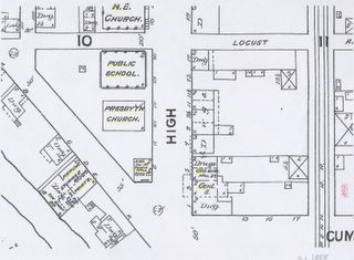
In 1888, Duncannons Public School was located on High Street next to the Presbyterian Church. The school suffered fire damage, was razed and now serves as a parking lot. Can you identify other uses which have changed in the intervening years such as the Town Hall? Sanborn used many abbreviations: for instance, Dwg for dwelling or Hardw for hardware store. Posted by Picasa

The Library of Congress makes available historic drawings. This one by T.M.Fowler of Duncannon in 1903, shows the public school that was built in 1873.Unfortunately, the "Hall" then used for elementary classes, suffered fire damage in 1954. It was eventually razed in 1965. Posted by Picasa

Two views to the square. Looking south, about 1925, and peering north on Market Street, about 1905. Posted by Picasa

Hotel Doyle celebrated its 100th anniversary in April 2005. Posted by Picasa

This Civil War flag is preserved at the Duncannon VFW Post 255. The VFW building was also the Paymaster's Office for the Duncannon Iron Co. Posted by Picasa

The names, dates and acreages of the original landowners in the Duncannon/Penn Township area of Perry County, Pa. Warrantee Maps of Perry County are available to inspect at The Perry Historians, P.O. Box 73, Newport, Pa 17074-0073. Posted by Picasa

Duncannon Views 3 and Links

CLICK on any photo or map to ENLARGE it; Right-Click to access the Save or Print Functions. SCROLL Down for LINKS to other Duncannon Views or to Email Izzy :-)
And, please -
Support The Perry Historians.
See old photos, maps, books and historic newspaper articles, as well as discover genealogical data about Duncannon and other Perry County communities - visit The Perry Historians. Located off Rt 34 between New Bloomfield and Newport, two (2) miles from the square in New Bloomfield, or four (4) miles from Newport. The Lenig Library is open most Wednesdays, 9 a.m. to 9 p.m. (717) 582-4896.